On our way to Las Vegas from the home of Bill & Colleen, we stopped at Hoover Dam. There we signed up for a tour of the powerhouse and the interior of the dam. Our guides were excellent, and we found the tour fascinating. Most of what follows we were told, but in fact I have refreshed my memory by doing some research on the internet.
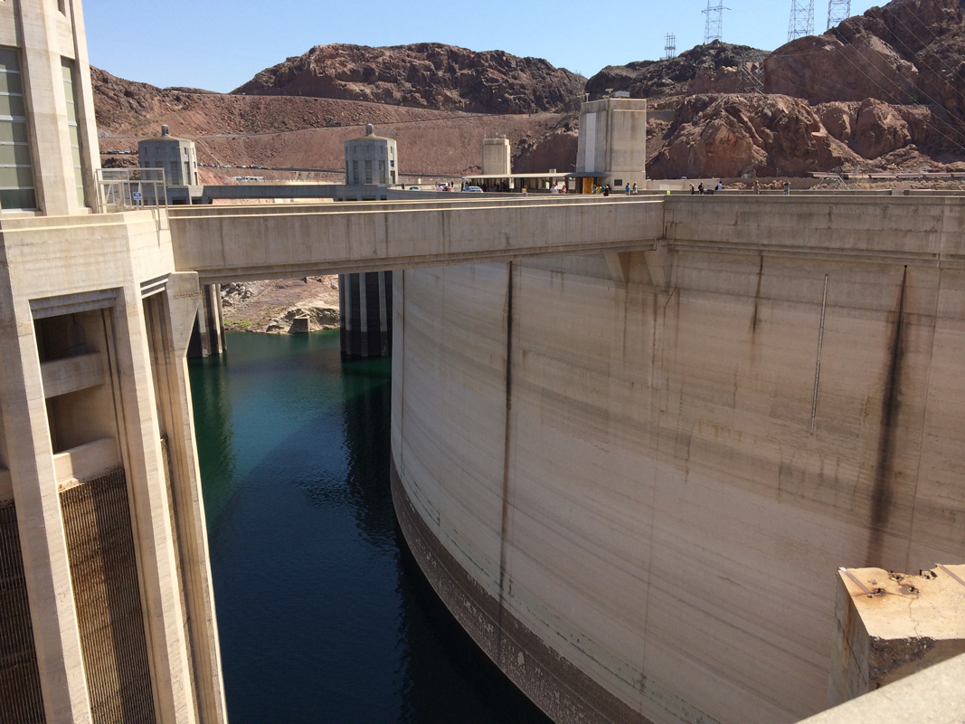
The design is a massive concrete arch-gravity dam. The monolithic dam is thick at the bottom and thin near the top, and presents a convex face towards the water above the dam. The curving arch of the dam transmits the water’s force into the abutments, in this case the rock walls of the canyon. The wedge-shaped dam is 660 ft thick at the bottom, narrowing to 45 ft at the top, leaving room for a highway connecting Nevada and Arizona, a highway that was supplanted in 2010 by the four-lane Hoover Dam Bypass due to security concerns following 9/11. The Dam rises 726 feet and is 1200 feet wide at its crest, and it took 91.8 billion cubic feet of concrete to create and weighs an estimated 6.6 million tons.
Hoover Dam was the most expensive engineering project in U.S. history at the time of its construction between 1931 and 1935, costing $49 million. Adjusted for inflation, it would have cost nearly $700 million to build in 2010. The Dam has become a major tourist attraction; nearly a million people tour the dam each year.
The Dam impounds Lake Mead, the largest reservoir in the United States by volume, but currently at very low levels due to regional drought.
Before the dam could be built, the Colorado River needed to be diverted away from the construction site. To accomplish this, four diversion tunnels were driven through the canyon walls, two on the Nevada side and two on the Arizona side. These tunnels were 56 feet in diameter.
To protect the construction site from the Colorado River and to facilitate the river’s diversion, two cofferdams were constructed. Work on the upper cofferdam began in September 1932, even though the river had not yet been diverted. The cofferdams were designed to protect against the possibility of the river flooding a site at which two thousand men might be at work. Once the cofferdams were in place and the construction site was drained of water, excavation for the dam foundation began. For the dam to rest on solid rock, it was necessary to remove accumulated erosion soils and other loose materials in the riverbed until sound bedrock was reached. Work on the foundation excavations was completed in June 1933. During this excavation, approximately 1,500,000 cubic yards of material was removed. Since the dam was an arch-gravity type, the side-walls of the canyon would bear the force of the impounded lake. Therefore the side-walls were excavated too, to reach virgin rock as weathered rock might provide pathways for water seepage. The men who removed this rock were called “high scalers”. While suspended from the top of the canyon with ropes, high-scalers climbed down the canyon walls and removed the loose rock with jackhammers and dynamite.
The first concrete was poured into the dam on June 6, 1933, 18 months ahead of schedule. Since concrete heats and contracts as it cures, the potential for uneven cooling and contraction of the concrete posed a serious problem. Bureau of Reclamation engineers calculated that if the dam was built in a single continuous pour, the concrete would take 125 years to cool and the resulting stresses would cause the dam to crack and crumble. Instead, the ground where the dam was to rise was marked with rectangles, and concrete blocks in columns were poured, some as large as 50 feet square and 5 feet high. Each five-foot form contained a series of 1 inch steel pipes through which first cool river water, then ice-cold water from a refrigeration plant was run. Once an individual block had cured and had stopped contracting, the pipes were filled with grout. Grout was also used to fill the hairline spaces between columns, which were grooved to increase the strength of the joins.
More than 582 miles of cooling pipes were placed within the concrete. Overall, there is enough concrete in the dam to pave a two-lane highway from San Francisco to New York. Concrete cores were removed from the dam for testing in 1995; they showed that “Hoover Dam’s concrete has continued to slowly gain strength” and the dam is composed of a “durable concrete having a compressive strength exceeding the range typically found in normal mass concrete”.
There were 112 deaths associated with the construction of the dam. The first was J. G. Tierney, a surveyor who drowned on December 20, 1922, while looking for an ideal spot for the dam. His son, Patrick W. Tierney, was the last man to die working on the dam, 13 years to the day later.
Chinese labor was forbidden by the construction contract, while the number of blacks employed never exceeded thirty, mostly lowest-pay-scale laborers in a segregated crew, who were issued separate water buckets. While on the tour we saw historic pictures of Navajo high scalars.
Denver artist Allen True was hired to handle the design and decoration of the walls and floors of the new dam. True’s design scheme incorporated motifs of the Navajo People and Pueblo tribes of the region. The images and colors are based on Native American visions of rain, lightning, water, clouds, and local animals — lizards, serpents, birds — and on the Southwestern landscape of stepped mesas.
Complementing True’s work, the Norwegian-born, naturalized American sculptor Oskar J.W. Hansen designed many of the sculptures on and around the dam. Hansen’s bas-relief on the Nevada elevator tower depicts the benefits of the dam: flood control, navigation, irrigation, water storage, and power. (See my photo, below.)
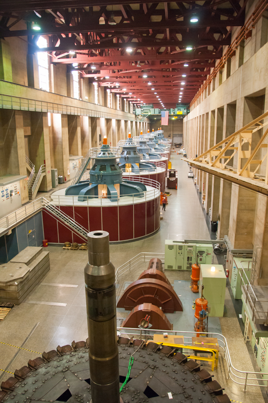
Before water from Lake Mead reaches the turbines, it enters the intake towers and enters four gradually narrowing penstocks which funnel the water down towards the powerhouse. The intakes provide a maximum hydraulic head (water pressure) of 590 ft as the water reaches a speed of about 85 mph. The entire flow of the Colorado River passes through the turbines.
Power generation has allowed the dam project to be self-sustaining: proceeds from the sale of power repaid the 50-year construction loan, and those revenues also finance the multi-million dollar yearly maintenance budget. Power is generated in step with and only with the release of water in response to downstream water demands. Lake Mead and downstream releases from the dam provide water for both municipal and irrigation uses. Water released from the Hoover Dam eventually reaches the All-American Canal for the irrigation of over 1,000,000 acres of land. Water from the lake serves 8 million people in Arizona, Nevada and California.
-

-
Dam front
-

-
Looking up into the lake from the dam
-

-
Barb on the dam w/ bypass bridge in background
-

-
Back side of dam
-

-
Hansen’s bas-relief
-

-
Pipes under the dam
-

-
Generating turbines on Nevada side (note size of man next to turbine)
-

-
Turbine armature removed for maintenance
-

-
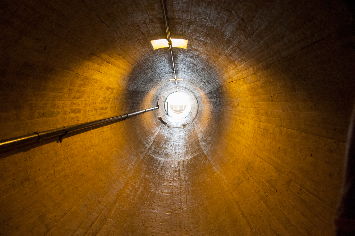
We passed thru this tunnel leading out to back face
-

-
Barb at vent at end of tunnel
-

-
Vertical panorama taken by Barb thru the vent
-

-
Stairs we would have taken back to the top had elevators failed
-

-
Panorama of Lake Mead
-

-
For comparison, Lake Mead in 2012