Category Archives: Arizona

Visiting Bill & Colleen — Parks, AZ, September 2-16, 2016

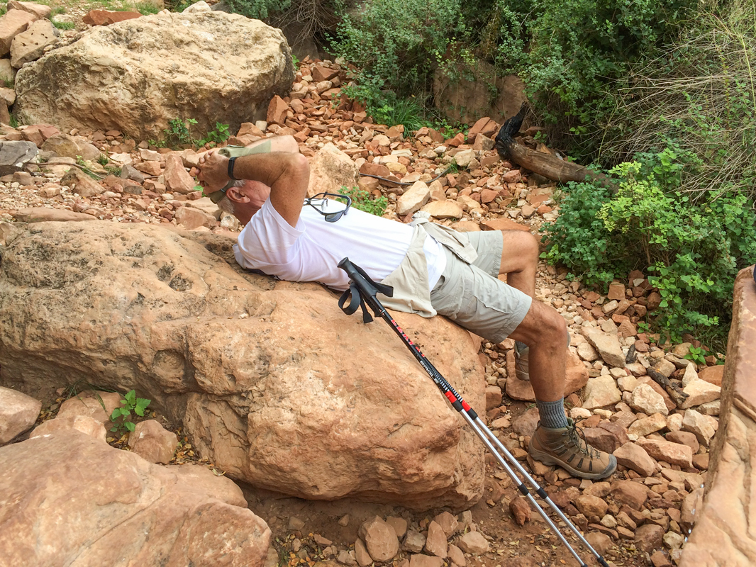
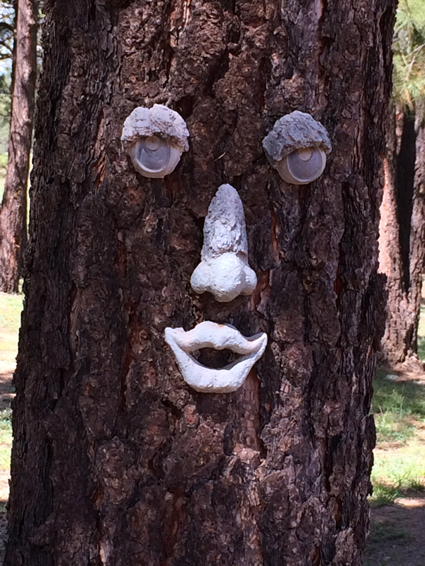
We had an enormously enjoyable and productive visit with Bill & Colleen.  New friends Bruce & Jan Dodge were also often present.  We met a number of Bill & Colleen’s neighbors at a Labor Day neighborhood gathering, and again when invited over to a couple’s home and again when Bill & Colleen threw a neighborhood BBQ rib party.  We had a number of ladderball tournaments.  We played Spades most evenings — the girls somehow managed to erase their previously abysmal record and humiliated the boys.  We took quite a few walks through woods and clearings looping around a nearby hill.  The weather was beautiful; the skies bright blue and temperatures mild.

While rooting around under the RV one day early in our visit (sealing all cracks to keep mice out), I discovered some cracked supports in one section of the structure that anchors the coach to the chassis.  And so yet another project was entered into — yet another example of the generosity and abilities of Bill, who borrowed a welder from a friend and scrounged up some angle iron and rectangular piping and proceeded to give me some experience with being the right-hand man of a metal worker.  We had to take off the rear wheels in order to get access to the area needing repair.  When we were finished, several days later, we looked up the specs and learned that the prescribed torque value for the lug nuts on the wheels was a surprising 465 lbs. or so.  Bill’s largest torque wrench topped out at 150 lbs.  What to do?  Bill and Bruce put their heads together and created a torque-mulitplying arm by welding a nut to a long metal arm at just the right position.  By attaching the torque wrench to the nut at the end of the arm,  the nominal value of 150 lbs. was actually 465 lbs.  Is there anything these two guys cannot do?

Lava River Cave is a lava tube cave in northern Arizona’s Coconino National Forest, accessible from Bill & Colleen’s by about 11 miles of gravel roads . At approximately 3/4-mile long, the cave is the longest of its kind known in Arizona. The cave was discovered by some lumbermen in 1915. Geologists believe the cave was formed sometime between 650,000 and 700,000 years ago when molten lava erupted from a nearby volcanic vent. The top, sides and bottom of the flow cooled and solidified, while lava in the middle flowed out, leaving a hollow space to form the cave. Examples of both ʻAʻā and Pāhoehoe basaltic lava can be seen in the cave.

The cave is mostly dry, but due to the temperature change, there is a lot of condensation on the walls, ceiling and floor near the entrance, which makes it slippery. Temperatures inside are around 40°F  during the summer, and it is not uncommon for some of the rocks to be covered with ice. The cave can range in height from 30 feet  to only 2 to 3 feet. There are no light sources inside.

Barb’s sister Audrey drove up from Las Vegas and joined us all for a few days.  She slipped on a slick rock in the cave and hurt her back, and so wasn’t able to complete the transit of the cave.  Barb hiked the first half and then decided she had had enough of dark caves and joined Audrey on the surface.

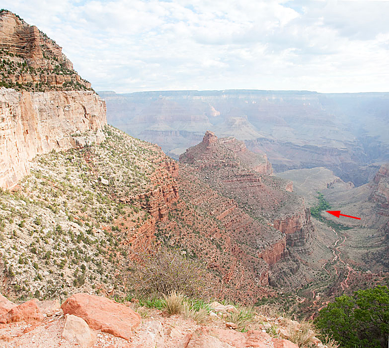
Walnut Canyon National Monument is a United States National Monument located about 10 mi  southeast of downtown Flagstaff, near Interstate 40. The canyon rim elevation is 6,690 ft; the canyon’s floor is 350 ft lower. A 0.9 mile long loop trail descends 185 ft into the canyon passing 25 cliff dwelling rooms constructed by the Sinagua, a pre-Columbian cultural group that lived in Walnut Canyon from about 1100 to 1250 CE.

Back in Flagstaff, we also visited the Riordan Mansion State Park, which features the duplex home of Timothy and Michael Riordan, lumber baron brothers who married sisters, Caroline and Elizabeth Metz. The brothers were members of an important Arizona Territorial family who played a role in the development of Flagstaff and northern Arizona and were involved in lumber, railroads, cattle, banking, and politics.

Cooperatively the Riordan brothers built their thirteen thousand square foot mansion in 1904 while Arizona was still a territory. The home consisted of two similar six thousand square foot wings for each family, connected by a large common room.

As we left early in the morning on September 16, we were bid adieu by Bill & Colleen and neighbor Willie and Bill’s friend Casey.

fairwell_photo

On Our Own, Again — Page, AZ, August 29-September 1, 2016

Horseshoe Bend, one of the most photographed areas on the Colorado River, is located just north of Grand Canyon and outside Page, Arizona.

Antelope Canyon is a slot canyon located on Navajo land east of Page, Arizona. The Navajo name for Upper Antelope Canyon means “the place where water runs through rocks.”

Antelope Canyon was formed by erosion of Navajo Sandstone, primarily due to flash flooding and secondarily due to other sub-aerial processes. Rainwater, especially during monsoon season, runs into the extensive basin above the slot canyon sections, picking up speed and sand as it rushes into the narrow passageways. Over time the passageways eroded away, making the corridors deeper and smoothing hard edges in such a way as to form characteristic ‘flowing’ shapes in the rock.

Flooding in the canyon still occurs. A flood occurred on October 30, 2006, that lasted 36 hours, and caused the Tribal Park Authorities to close Lower Antelope Canyon for five months.

Antelope Canyon is a popular location for photographers and sightseers, and a source of tourism business for the Navajo Nation. Private tour companies have been permitted to offer tours since 1987. It has been accessible by tour only since 1997, when the Navajo Tribe made it a Navajo Tribal Park. Photography within the canyons is difficult due to the wide exposure range (often 10 EV or more) made by light reflecting off the canyon walls.  (My pictures within the canyon were made by taking multiple pictures at varying levels of exposure and then combining them using HDR (High Dynamic Range) software in Adobe Photoshop CS6.)

In the 1940s and early 1950s, the  U.S. Bureau of Reclamation planned to construct a series of Colorado River dams in the rugged Colorado Plateau province of Colorado, Utah, and Arizona. Glen Canyon Dam was born of a controversial damsite the Bureau selected in Echo Park, in what is now Dinosaur National Monument in Colorado. A small but politically effective group of objectors led by David Brower of the Sierra Club succeeded in defeating the Bureau’s bid, citing Echo Park’s natural and scenic qualities as too valuable to submerge. By agreeing to a relocated damsite near Lee’s Ferry between Glen and Grand Canyons, however, Brower did not realize what he had gambled away. At the time, Brower had not actually been to Glen Canyon. When he later saw Glen Canyon on a river trip, Brower discovered that it had the kind of scenic, cultural, and wilderness qualities often associated with America’s national parks. Over 80 side canyons in the colorful Navajo Sandstone contained clear streams, abundant wildlife, arches, natural bridges, and numerous Native American archeological sites. By then, however, it was too late to stop the Bureau from building Glen Canyon Dam.

Emboldened by Echo Park and desperate to protect the Grand Canyon from a similar fate as Glen, Brower and the Sierra Club directed attention towards the proposed Bridge and Marble dams. The Sierra Club launched an extensive publicity campaign to sway public opinion against the plan; in response to the USBR’s argument that new reservoirs would open up the Grand Canyon to recreational boaters as Lake Powell had, a full-page advertisement in the New York Times ran the slogan: “Should we also flood the Sistine Chapel so tourists can float nearer the ceiling?” Faced with a tremendous outcry, the Bureau abandoned its Grand Canyon dams, effectively terminating most of the Pacific Southwest Water Plan, in 1968. The coal-fired Navajo Generating Station was built near Page, to make up for the electric power that was lost with the cancellation of the dam project. The Sierra Club lost its IRS tax-exempt status a day after the advertisement was released; ostensibly, this was due to its disruptive political activities. However, the group’s membership more than doubled in the next three years, many of them citizens unhappy with the IRS’ action.

The Glen Canyon Bridge or Glen Canyon Dam Bridge is the steel arch bridge carrying U.S. Route 89 across the Colorado River. The bridge was originally built by the United States Bureau of Reclamation to facilitate transportation of materials for the Glen Canyon Dam, which lies adjacent to the bridge just 865 feet upstream. Carrying two lanes, the bridge rises over 700 feet above the river and was the highest arch bridge in the world at the time of its completion in 1959.

Lake Powell, straddling the border between Utah and Arizona, is the reservoir on the Colorado River created by Glen Canyon Dam. The reservoir is named for explorer John Wesley Powell, a one-armed American Civil War veteran who explored the river via three wooden boats in 1869. It is a major vacation spot that around 2 million people visit every year. It is the second largest man-made reservoir by maximum water capacity in the United States behind Lake Mead. However, due to high water withdrawals for human and agricultural consumption, and because of subsequent droughts in the area, Lake Powell is currently larger than Mead. The existence of the reservoir led to the creation of Glen Canyon National Recreation Area in 1972, a popular summer destination on public land managed by the National Park Service.

Lake Powell is a water storage facility for the Upper Basin states of the Colorado River Compact (Colorado, Utah, Wyoming, and New Mexico). The Compact specifies that the Upper Basin states are to provide a minimum annual flow of 7,500,000 acre feet to the Lower Basin states (Arizona, Nevada, and California).

Approximately 12 miles from Page, and 9 miles from Glen Canyon Dam, is an unusual campground:  Lone Rock Beach Primitive Camping, featuring camping on a sandy beach or in dunes with no designated campsites.  Open fires are permitted, but must be within a four foot squared area. There are 4 micro flush toilets, 6 vault toilets, 1 comfort station/wheelchair accessible, and an outdoor cold shower, There is an Off Road Vehicle area, a dump station, potable water (seasonal), and a day use area. No launch ramp. $14 per vehicle/per night. (But no charge to Golden Age Passport holders.)  No reservations.

The site is named for Lone Rock, a large isolated redrock formation.

[Facts in this post gleaned from several Wikipedia posts.  Opinions are those of this blog’s authors.]

Hoover Dam — September 12, 2014

On our way to Las Vegas from the home of Bill & Colleen, we stopped at Hoover Dam.  There we signed up for a tour of the powerhouse and the interior of the dam.  Our guides were excellent, and we found the tour fascinating.  Most of what follows we were told, but in fact I have refreshed my memory by doing some research on the internet.

The design is a massive concrete arch-gravity dam. The monolithic dam is thick at the bottom and thin near the top, and presents a convex face towards the water above the dam. The curving arch of the dam transmits the water’s force into the abutments, in this case the rock walls of the canyon. The wedge-shaped dam is 660 ft thick at the bottom, narrowing to 45 ft at the top, leaving room for a highway connecting Nevada and Arizona, a highway that was supplanted in 2010 by the four-lane Hoover Dam Bypass due to security concerns following 9/11. The Dam rises 726 feet and is 1200 feet wide at its crest, and it took 91.8 billion cubic feet of concrete to create and weighs an estimated 6.6 million tons.

Hoover Dam was the most expensive engineering project in U.S. history at the time of its construction between 1931 and 1935, costing $49 million. Adjusted for inflation, it would have cost nearly $700 million to build in 2010.   The  Dam has become a major tourist attraction; nearly a million people tour the dam each year.

The Dam impounds Lake Mead, the largest reservoir in the United States by volume, but currently at very low levels due to regional drought.

Before the dam could be built, the Colorado River needed to be diverted away from the construction site. To accomplish this, four diversion tunnels were driven through the canyon walls, two on the Nevada side and two on the Arizona side. These tunnels were 56 feet in diameter.

To protect the construction site from the Colorado River and to facilitate the river’s diversion, two cofferdams were constructed. Work on the upper cofferdam began in September 1932, even though the river had not yet been diverted. The cofferdams were designed to protect against the possibility of the river flooding a site at which two thousand men might be at work. Once the cofferdams were in place and the construction site was drained of water, excavation for the dam foundation began. For the dam to rest on solid rock, it was necessary to remove accumulated erosion soils and other loose materials in the riverbed until sound bedrock was reached. Work on the foundation excavations was completed in June 1933. During this excavation, approximately 1,500,000 cubic yards of material was removed. Since the dam was an arch-gravity type, the side-walls of the canyon would bear the force of the impounded lake. Therefore the side-walls were excavated too, to reach virgin rock as weathered rock might provide pathways for water seepage. The men who removed this rock were called “high scalers”. While suspended from the top of the canyon with ropes, high-scalers climbed down the canyon walls and removed the loose rock with jackhammers and dynamite.

The first concrete was poured into the dam on June 6, 1933, 18 months ahead of schedule. Since concrete heats and contracts as it cures, the potential for uneven cooling and contraction of the concrete posed a serious problem. Bureau of Reclamation engineers calculated that if the dam was built in a single continuous pour, the concrete would take 125 years to cool and the resulting stresses would cause the dam to crack and crumble. Instead, the ground where the dam was to rise was marked with rectangles, and concrete blocks in columns were poured, some as large as 50 feet square and 5 feet high. Each five-foot form contained a series of 1 inch steel pipes through which first cool river water, then ice-cold water from a refrigeration plant was run. Once an individual block had cured and had stopped contracting, the pipes were filled with grout. Grout was also used to fill the hairline spaces between columns, which were grooved to increase the strength of the joins.

More than 582 miles of cooling pipes were placed within the concrete. Overall, there is enough concrete in the dam to pave a two-lane highway from San Francisco to New York. Concrete cores were removed from the dam for testing in 1995; they showed that “Hoover Dam’s concrete has continued to slowly gain strength” and the dam is composed of a “durable concrete having a compressive strength exceeding the range typically found in normal mass concrete”.

There were 112 deaths associated with the construction of the dam. The first was J. G. Tierney, a surveyor who drowned on December 20, 1922, while looking for an ideal spot for the dam. His son, Patrick W. Tierney, was the last man to die working on the dam, 13 years to the day later.

Chinese labor was forbidden by the construction contract, while the number of blacks employed never exceeded thirty, mostly lowest-pay-scale laborers in a segregated crew, who were issued separate water buckets. While on the tour we saw historic pictures of Navajo high scalars.

Denver artist Allen True was hired to handle the design and decoration of the walls and floors of the new dam. True’s design scheme incorporated motifs of the Navajo People and Pueblo tribes of the region. The images and colors are based on Native American visions of rain, lightning, water, clouds, and local animals — lizards, serpents, birds — and on the Southwestern landscape of stepped mesas.

Complementing True’s work, the Norwegian-born, naturalized American sculptor Oskar J.W. Hansen designed many of the sculptures on and around the dam. Hansen’s bas-relief on the Nevada elevator tower depicts the benefits of the dam: flood control, navigation, irrigation, water storage, and power. (See my photo, below.)

Before water from Lake Mead reaches the turbines, it enters the intake towers and enters four gradually narrowing penstocks which funnel the water down towards the powerhouse. The intakes provide a maximum hydraulic head (water pressure) of 590 ft as the water reaches a speed of about 85 mph. The entire flow of the Colorado River passes through the turbines.

Power generation has allowed the dam project to be self-sustaining: proceeds from the sale of power repaid the 50-year construction loan, and those revenues also finance the multi-million dollar yearly maintenance budget. Power is generated in step with and only with the release of water in response to downstream water demands. Lake Mead and downstream releases from the dam provide water for both municipal and irrigation uses. Water released from the Hoover Dam eventually reaches the All-American Canal for the irrigation of over 1,000,000 acres of land. Water from the lake serves 8 million people in Arizona, Nevada and California.

Visit to Bill/Colleen, Part 2 — Grand Canyon, September 6-9, 2014

We had a thoroughly enjoyable time during our visit with Bill & Colleen.  All of it.  But the highlight of the visit has to be our multi-day camping trip to the southern rim of Grand Canyon.  Bill & Colleen own a perfectly comfortable and commodious fifth wheel camper, but as luck would have it, Bill’s boss had graciously offered Bill the use of his ginormous ShowHauler camper as a reward for Bill having found and fixed a number of problems with the beast.  Bill accepted, but delayed cashing in on the offer until we could arrive and share the bounty with him.  Have I mentioned that the ShowHauler is HUGE?  When we pulled into the parking lot of the IMAX theatre, we were immediately surrounded by at least 20 tourists who simply HAD to get a picture!

Bill is an active and accomplished hiker who has many many times walked all the way down one side of the canyon and up the other, spent the night, and then repeated the hike in reverse order the next day.  But knowing the physical limitations of Barb and me (especially), he wisely suggested that we descend only about half way and then return to our starting point.  Normally, Colleen would be perfectly capable of such a feat, but since she was suffering from a severe cold and/or allergy attack, she elected to remain in the camper while we indulged in an awesome “stroll”.

Bill suggested that we take the Bright Angel Trail down about 4 ½ miles to the Indian Garden site, some 3,040 feet below the rim, where a spring has created a surprising and remarkable oasis.  The trail is sometimes steep and sometimes not so much, sometimes wide and sometimes not so much, but always navigable by the pack of mules that carry the tourists less ambitious and/or fit than ourselves.  Barb wears a fitbit and runs a “Map my Track” app on her iPhone.  Interestingly enough, they reported that we went almost 11 miles rather than the expected 9.  We took only a minimum amount of water with us, knowing that we could replenish our supply at each of the rest station cabins that came every 1 ½ miles.  (On our way back up, we rested a good bit more often than every rest station.)

It goes without saying that the Canyon is visually awe inspiring, but we were also impressed by the infrastructure provided by the National Park Service.  Free shuttle buses, informative displays, interesting Park Ranger programs and well-equiped and maintained campgrounds.  Everything first class.

On two days subsequent to the hike, we visited by car and by foot some of the other vistas along the southern rim, ending our visit at the Desert View Watchtower, a 70-foot-high stone building more than 20 miles to the east of the main developed area at Grand Canyon Village. The four-story structure, completed in 1932, was designed by American architect Mary Colter. The tower was designed to resemble an Ancient Pueblo Peoples watchtower. The base was intentionally designed to convey a partly ruinous appearance, perhaps of an older structure on which the watchtower was later built. The base is arranged within a large circle with the tower to the north. Tiny windows are irregularly arranged, some of which are themselves irregular in shape. The main space is the Kiva Room in the base structure. (Faithful readers will recognize the significance of “Kiva Room” from our earlier posting about Mesa Verde.)

One other thing deserves mention about our Canyon experience:  the repeated presence of elk in the campground, grazing with perfect aplomb and indifference to the tourists frantically taking photographs from only a few yards away.

All in all, the camping trip to the Canyon was a fantastic experience for which we owe an enormous amount of gratitude to Bill and Colleen.

Visit to Bill/Colleen, Part 1 — Arizona; September 4-11, 2014

Our trip into the Southwest has been filled with interesting sights and experiences.  As we left our Mesa Verde campsite on September 4, Barb grabbed a shot of two young fawns and their mother.  As we made our way toward the home of Bill & Colleen (Dolce Vita), we passed through increasingly dry and dramatic landscapes.  We anticipated stopping at the exact spot of Four Corners and spread-eagling onto four states at once.  Alas, the spot is not public property and we left disappointed.  Bill & Colleen were terrific hosts, and we had a great time — so much so that I have decided to break up my coverage into two parts, with this part being the bookends that enclose our hike into Grand Canyon, covered in the next part.

Early in the visit Bill took Barb & I to a nearby box canyon where Amerindians used to corner game for hunting, and where they left rather extensive petroglyphs.  After our multi-day visit to Grand Canyon we had a day of rest while Barb recovered from a cold and/or an attack of allergies, and we then went on a day trip that included a visit to beautiful Sedona, quirky Jerome, and the bustling city of Prescott, site of the recent tragic deaths of firefighters but more to the point, the location of the beautiful piece of land upon which Bill & Colleen will eventually build.  We also took advantage of Bill’s remarkable ability to help others; he accompanied us on a preliminary visit to a dealer of campers and he master-minded the repair of a zipper on the tent Barb & I have been using for our car-camping adventures.

Bill & Colleen’s home is super-nice and in a great setting.   In the evenings we sometimes heard coyotes yipping in the distance, and on our last night we heard bull elk bugling and cow elk mewing. Neat!