When we left the Minneapolis area our destination was Sisseton, in Roberts County, in the extreme northeastern corner of South Dakota. “Sisseton” is an anglicization of the Dakota Indian words “Sinsin Tunwan” (also rendered as “Sissetowan”), which means “Swamp Village”. Sisseton is the largest town in the Lake Traverse Reservation, homeland of the Sisseton Wahpeton Oyate, a branch of the Santee Dakota group of Native Americans. The Shipleys used to live about 10 miles south of Sisseton on what was (and still is) called the “Valley Ranch”. Dad was the foreman there and the mechanic for all of a set of farms and ranches owned by A.W. Powell, the president of a Sisseton bank. My sister Zona and I attended a one-room country grade-school about two miles from our farm (and of course we had to walk uphill both ways whenever the weather was less than a full-scale blizzard.) Valley Ranch was just below a range of hills (the Coteau des Prairies) that had been laid down by receding glaciers in the ice age. Up on the ridge of the hills, about a mile from our former home, is the grave site of Gabriel Renville (1824–1892), the last chief of the Sissetowan and Wahpetowan. I spent much of my childhood playing with the direct descendants of Chief Renville. Later, I drove a Model A Ford about 10 miles north to Sisseton for my freshman year of high school, and then we all moved to Romulus, MI for two years before returning to the prairie states to Jamestown, ND in time for my senior year.
So there was a reason to stop at Sisseton with our camper. We settled in to the only campground in the immediate area (Camp Dakotah), and were joined the next day by Mom and Zona. We had all long talked about visiting the old stomping grounds, and now we were making it happen!
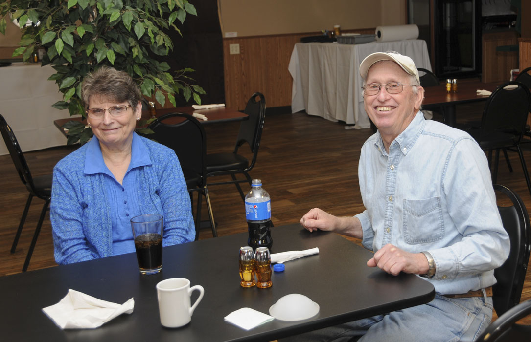
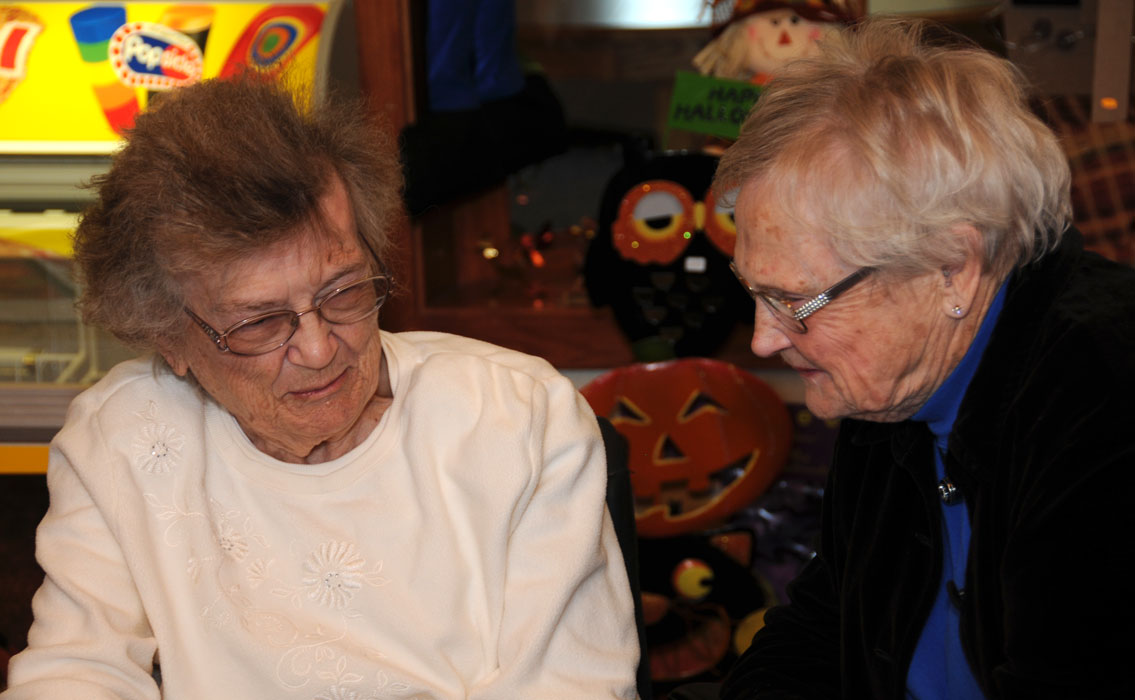
Mom and Zona had made some phone calls that enabled us to get together for a number of conversations with contemporaries of Mom and with childhood friends of Zona and I. Coffee with Luella George and her son Donald (and his wife Linda). Breakfast with Luella’s son Phillip and daughter Shannon and with friend Calvin Hove and his wife. A visit to an assisted-living facility to see Phyllis Karst, where we were joined by her daughter Judy Karst Nelson and son Paul Karst. And another visit to see my folks’ friend Milton Leiseth, whose wife Jeanne, now deceased, had taught Zona and I in the one-room school. The visits were as enjoyable as we had expected and we all came away congratulating ourselves for finally making it happen.
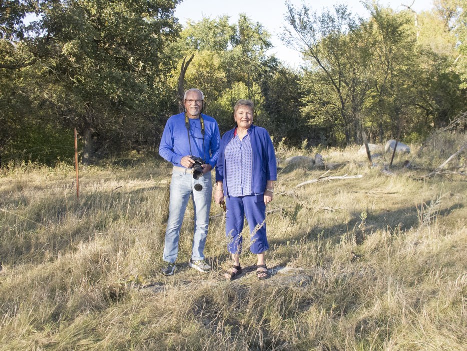
The four of us also visited the old farm, which still bears the name “Valley Ranch”. As we stopped at the beginning of the long driveway to photograph the arch over the cattle guard, the new owner, Calvin Finnesand, happened by on a 4-wheeler on his way to check his cattle. He gladly gave us permission to poke around the grounds where we used to live. We already knew that there had been many changes, but were anxious to see if we could find the site of our former home. We knew that part of the house had been moved away and converted into a granary, and that the attached addition (formerly Mom & Dad’s bedroom) had been retained on the ranch but moved and converted to a bunkhouse. All of the former barns had long ago collapsed. The bridge that had formerly crossed the adjacent creek had also mostly collapsed, and a huge tree had grown up right in the middle of the approach. All of which were initially surprising and distressing, until we remembered that we had been gone for over 55 years. It took a while, but we had a small victory in finding the foundation of our former home.
We all took a trip in to Peever, SD, the little town east of the Valley Ranch, where the Shipley family had originally gone in to shop on Saturday nights. The association of Peever and Shipleys was long-standing: Mom and her siblings went to school there. For a time in my childhood, the Chamber of Commerce of Peever had paid Dad to show free movies on summer Saturday nights. Several sheets sewn together served as the screen, and Dad had speakers and a projector capable of showing films of commercial format. But he only had one projector, so every 20 minutes there was a pause while he changed the reel. Folks pulled their cars onto the vacant lot and watched from the comfort of their vehicles, or while sitting on blankets on the ground. Afterwards, many bought groceries at one of two small stores. And we almost always stopped at the Hanson cafe for coffee and pie or a cheeseburger and malted milk. The grocery stores are long gone, as is the cafe. As is the Lang general store that used to be across from the cafe. The schools are all gone; students are now bussed into Sisseton. The only occupied commercial buildings remaining are a liquor store and the Post Office, and the latter is scheduled to be closed. Remarkably, the two poles that supported Dad’s movie screen are still there!
We all also took a drive north and west of Sisseton, where we visited Sica Hollow. “Sica” means “bad” in the Dakota Indian language; did I mention that I grew up on the Sisseton/Wahpeton Oyate Reservation? The state park has a number of horse trails and a few campsites that seemed to be largely intended for hosting folks who have brought in horses on trailers. And then we stopped at the relatively new Nicollet tower, built at the initiative of Harold L. Torness, a banker and lifelong resident of Sisseton and the successor and son-in-law of A.W. Powell. Torness was so fascinated by the book “Joseph N. Nicollet on the Plains and Prairies: The Expeditions of 1838-39 with Journals, Letters, and Notes on the Dakota Indians” that he spearheaded a $335-thousand fund-raising campaign to build a monument to the explorer. In a breathtaking view from the top of the tower, visitors can see the states of South Dakota, North Dakota, and Minnesota, six counties, 11 communities and the Continental Divide. An adjacent 2,400-square-foot interpretive center has displays and classroom space.
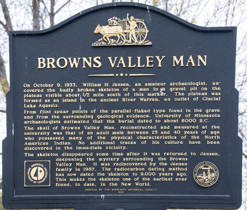
After Mom and Zona had returned to Bismarck, Barb and I went on several other expeditions. We went east and south to the village of Browns Valley, located on the southern-most end of Traverse, a long narrow lake on the border of South Dakota and Minnesota that transformed from a north-flowing river to a lake when it was blocked by glaciers in the ice age. Another trip was to the south and west of Sisseton to Lake Enemy Swim, where the Shipleys used to go to swim and picnic 60 years ago. We stopped at Waubay National Wildlife Refuge where we climbed a fire watchtower. Closer to Sisseton, we stopped to see the Buffalo Lake Church, an old “Norwegian” Lutheran church that had been mentioned by the proprietress Marsha of our campground. Marsha, incidentally, also told me that as a child her family used to go to Dad’s movies in Peever. On the way back to Sisseton from the Buffalo Lake Church, we drove down a gravel road past a field filled with — are you ready for this? — a huge herd of bison!
When at last we left Sisseton, we drove northward to visit a cousin of Barb near Grandin, North Dakota. Tune in next time.
-

-
Speaking with Calvin Finnesand, present owner of Valley Ranch
-

-
Chuck & Zona standing on foundation of former home
-

-
Peering into folks’ former bedroom.
-

-
What is left of Peever commerce
-

-
Poles used 60 years ago by Bill Shipley to show outdoor movies in Peever
-

-
Luella George
-

-
Linda & Donald George
-

-
Shipleys & Georges
-

-
Zona at one of the reunions
-

-
Calvin Hove
-

-
Another reunion: Barb, Shannon, Phillip, Calvin’s wife, and Calvin
-

-
Phillip, Calvin & Chuck
-

-
Paul & Phyllis Karst & Judy Karst Nelson
-

-
Zona & Phyllis
-

-
Judy
-

-
Chuck, Judy, Mom & Zona
-

-
Mom & Phyllis
-

-
Chuck, Phyllis & Mom
-

-
Mom, Zona & Barb
-

-
Sumac near Sica Hollow
-

-
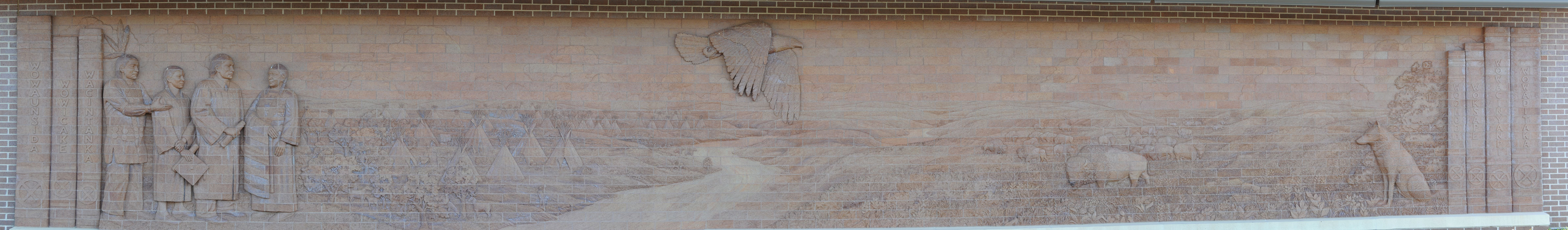
Sisseton-Wahpeton Tribal Headquarters at Agency Village
-

-
“Song to the Great Spirit”, the new Sisseton Wahpeton College Vocational Education Building at Agency Village
-

-
Exterior wall of library at Agency Village
-

-
Sign at Tribal Headquarters
-

-
Barb from atop fire tower in Waubay National Wildlife Refuge near Lake Enemy Swim
-

-
She has always looked up to me
-

-
Pan from atop the fire tower
-

-
Seen from country road on Reservation; Sun Dance site?
-

-
White Pelicans in distant slough
-

-
Suddenly, a field of Bison!
-

-
Small portion of huge herd
-

-
Memorial for Dakota Chief Blue Dog (near Lake Enemy Swim)
-

-
Other side of memorial
-

-
“Norwegian” Lutheran Church in hills near Buffalo Lake
-

-
Church sign
-

-
Organ in Church
-

-
Altar in Church
-

-
Tool used to decorate ceiling in Church
-

-
Closeup of hymnal books on organ. Note language.
-

-
South end of Lake Traverse, on border between South Dakota and Minnesota
-

-
Barb climbing up dike protecting Browns Valley from Lake Traverse
-

-
Historical marker in Browns Valley, MN
-

-
Sign at Brown’s Valley
-

-
Chuck at Lake Traverse
-

-
Combining soy beans near Browns Valley
-

-
Trailer for transporting harvested crops from combine to large truck
-

-
Downy Woodpecker
-

-
Osprey